Using PostGIS and pg_featureserv with QGIS
My colleague Kat Batuigas recently wrote about using the powerful open-source QGIS desktop GIS to import data into PostGIS from an ArcGIS Feature Service. This is a great first step toward moving your geospatial stack onto the performant, open source platform provided by PostGIS. And there's no need to stop there! Crunchy Data has developed a suite of spatial web services that work natively with PostGIS to expose your data to the web, using industry-standard protocols. These include:
- pg_tileserv - allows mapping spatial data using the MVT vector tile format
- pg_featureserv - publishes spatial data using the OGC API for Features protocol
Recent versions of QGIS support using the OGC API for Features (previously
known as WFS3) as a vector data source. So it should be able to source data from
pg_featureserv.
Let's see how it works.
Load Data into PostGIS
To keep things simple we are using a
Crunchy Bridge
cloud-hosted Postgres/PostGIS instance. For demo purposes we'll load a dataset
of British Columbia wildfire perimeter polygons (available for download
here). The
data is provided as a shapefile, so we can use the PostGIS
shp2pgsql
utility to load it into a table. (If the data was in another format then we
could load it using ogr2ogr, or use
QGIS itself as Kat described).
We use the -c option to have the loader create a table appropriate for the
dataset, and the -I option to create a spatial index on it (always a good
idea). The data is in the BC-Albers coordinate system, so we specify the SRID
using as -s 3005. Here we are doing the load in two steps using an
intermediate SQL file, or it can be done in a single command by piping the
shp2pgsql output to psql.
shp2pgsql -c -D -s 3005 -i -I prot_current_fire_polys.shp bc.wildfire_poly > bc_wf.sql
psql -h p.asdfghjklqwertyuiop12345.db.postgresbridge.com -U postgres < bc_wf.sql
Using psql we can connect to the database and verify that the table has been
created and loaded:
postgres=# \d bc.wildfire_poly
                                            Table "bc.wildfire_poly"
   Column   |            Type             | Collation | Nullable |                    Default
------------+-----------------------------+-----------+----------+-----------------------------------------------
 gid        | integer                     |           | not null | nextval('bc.wildfire_poly_gid_seq'::regclass)
 objectid   | double precision            |           |          |
 fire_year  | integer                     |           |          |
 fire_numbe | character varying(6)        |           |          |
 version_nu | double precision            |           |          |
 fire_size_ | numeric                     |           |          |
 source     | character varying(50)       |           |          |
 track_date | date                        |           |          |
 load_date  | date                        |           |          |
 feature_co | character varying(10)       |           |          |
 fire_stat  | character varying(30)       |           |          |
 fire_nt_id | integer                     |           |          |
 fire_nt_nm | character varying(50)       |           |          |
 fire_nt_lk | character varying(254)      |           |          |
 geom       | geometry(MultiPolygon,3005) |           |          |
Indexes:
    "wildfire_poly_pkey" PRIMARY KEY, btree (gid)
    "wildfire_poly_geom_idx" gist (geom)

 postgres=# select count(*) from bc.wildfire_poly;
 count
-------
   133
Serve PostGIS Data with pg_featureserv
The Crunchy spatial services are lightweight native applications (written in Go), so it's easy to install them on a local or hosted platform. They can be downloaded as applications, a Docker container, or built from source. See the installation guide for details.
We're running pg_featureserv in a local environment. To connect it to the
Bridge Postgres instance, we specify the database connection information in the
config/pg_featureserv.toml file. The connection string can also be specified
in an environment variable. See the
documentation
for more information.
[Database]
# Database connection
# postgresql://username:password@host/dbname
DbConnection = "postgres://postgres:password@p.asdfghjklqwertyuiop12345.db.postgresbridge.com:5432/postgres"
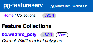
For ease-of-use pg_featureserv provides a browser-based Admin UI. Using this
we can see the data table published as a collection:
http://localhost:9000/collections.html
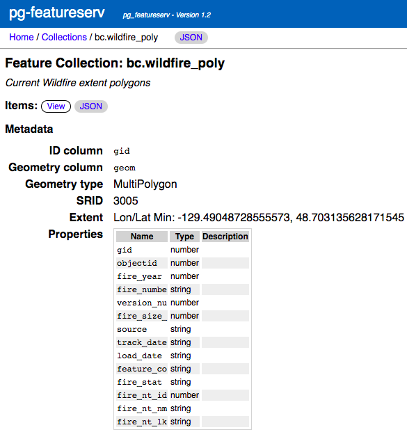
We can display the the collection metadata:
http://localhost:9000/collections/bc.wildfire_poly.html
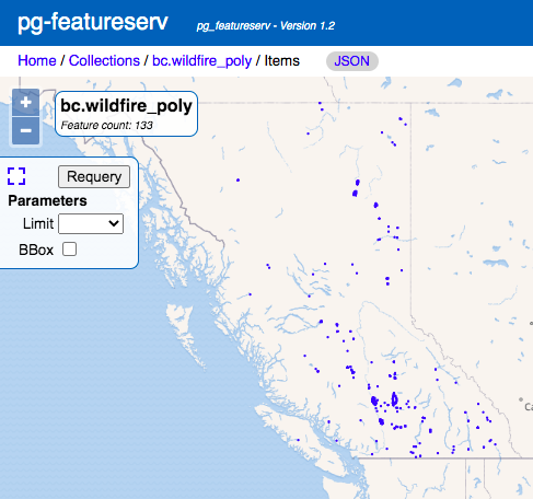
The Admin UI also lets us see the data on a map:
http://localhost:9000/collections/bc.wildfire_poly/items.html?limit=200
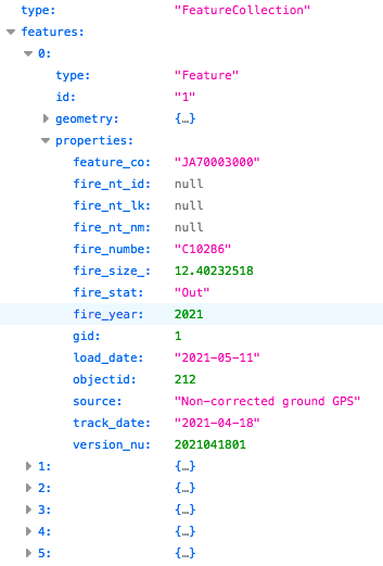
The main use of pg_featureserv is to serve feature data via the OGC API
for Features (OAPIF), which is a RESTful HTTP protocol
returning GeoJSON. We can verify that a OAPIF data query works by issuing the
following request URL. The response is a GeoJSON document (shown here using the
handy JSON display in the Firefox browser):
http://localhost:9000/collections/bc.wildfire_poly/items.json
Display pg_featureserv Collection as a QGIS Layer
In QGIS, we can create a layer that displays the data coming from the
pg_featureserv instance.
To do this, under the Layer menu choose Add Layer > Add WFS Layer**...**.
This displays the Data Source Manager window at the WFS/OGC API-Features tab.
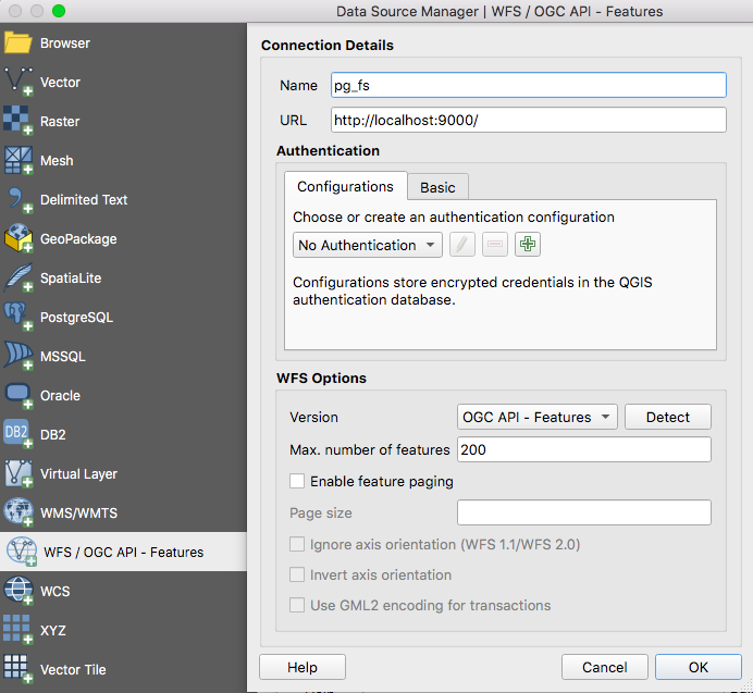
Click New to define the connection to the pg_featureserv service. The
Connection Details dialog lets us enter the following information:
- We'll use
pg_fsas the name of the connection - The connection URL is the service home endpoint
http://localhost:9000/ - The WFS Version is OGC API - Features
- We'll specify the Max. number of features as 200, since that will allow loading the entire dataset without paging
When we click Connect we see the collections published by the service (in this demo there is only one):
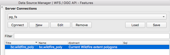
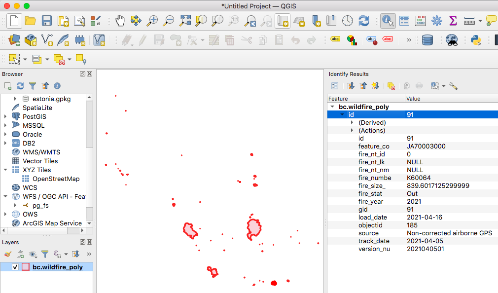
Now we can select the bc.wildfire_poly collection, and click Add to add it as
a layer to the QGIS map layout. The screenshot also shows the result of using
the Identify Features tool on the map, showing that all attribute data is loaded
as well.
Of course, QGIS is able to connect to PostGIS directly, and provides full query and update capability when doing that. But it can be simpler, more flexible and more secure to expose PostGIS data via a web service. That way, it can be easily accessed by many different tools which might not be able to or allowed to connect to PostGIS directly.
We're also exploring ways to be able to run pg_tileserv and pg_featureserv
directly in Crunchy Bridge, to provide a turn-key solution for exposing spatial
data on the web. If this sounds interesting to you,
get in touch!
